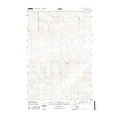
2016 Map of Valdez B-6 NW
USGS Topo · Published 2016About this map
The Ted Stevens Icefield anchors this high-altitude landscape in the Chugach Mountains, where ice and rock define the terrain. Glacial movement is central to the local geography, with the Stephens Glacier and Klutina Glacier serving as the primary sources for the area's drainage systems. Meltwater from these expansive ice bodies feeds into the Klutina River and Stephens Creek, illustrating the transition from frozen icefields to alpine waterways. Rising above the glacial basins are several prominent summits, including Garrett Peak, Mt Ourand, and Mt Evans, which mark the highest points of the local ridges. This map captures the unorganized territory at a time when surveying was conducted through a collaboration between the U.S. Geological Survey and agencies such as the Alaska Dept. of Transportation, providing a detailed look at the ice-to-water cycle in the Alaska wilderness.
Find a feature on this map
14 named features on this map. Tap any name to fly to it.
Don’t see what you’re looking for? This feature index may not catch every label — zoom into the map to look around manually.
Map Details
Editions of this 2016 Valdez B-6 NW Map
This is the sole edition of this map. No revisions or reprints were ever made.
Other maps of this area

1950 · Valdez C-6
USGS Topo · 1:63,360

1951 · Valdez B-6
USGS Topo · 1:63,360

1952 · Valdez
USGS Topo · 1:250,000

1953 · Valdez C-6
USGS Topo · 1:63,360

1953 · Valdez B-6
USGS Topo · 1:63,360

1960 · Valdez B-7
USGS Topo · 1:63,360

1960 · Valdez C-7
USGS Topo · 1:63,360

1960 · Valdez
USGS Topo · 1:250,000
1993 · Valdez C-6
USGS Topo · 1:63,360
1993 · Valdez C-7
USGS Topo · 1:63,360