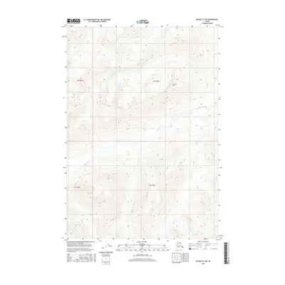
2016 Map of Valdez C-6 SW
USGS Topo · Published 2016About this map
Terrace Mtn dominates the northern reaches of this high-elevation Alaskan terrain, where glacial valleys and steep ridgelines define the landscape. The southwesterly flow of the Hallet River carves through the central portion of the quadrangle, serving as the primary drainage for the surrounding slopes. The map detail reflects the Public Land Survey System divisions between t3s r6w, t3s r5w, t4s r6w, and t4s r5w, highlighting how even this undeveloped backcountry was organized by federal surveyors. This 2016 edition provides a modern topographic baseline of the area's wilderness character, capturing a period of contemporary environmental study and land management in the Unorganized Borough.
Find a feature on this map
6 named features on this map. Tap any name to fly to it.
Don’t see what you’re looking for? This feature index may not catch every label — zoom into the map to look around manually.
Map Details
Editions of this 2016 Valdez C-6 SW Map
This is the sole edition of this map. No revisions or reprints were ever made.
Other maps of this area

1950 · Valdez C-6
USGS Topo · 1:63,360

1951 · Valdez B-6
USGS Topo · 1:63,360

1952 · Valdez
USGS Topo · 1:250,000

1953 · Valdez C-6
USGS Topo · 1:63,360

1953 · Valdez B-6
USGS Topo · 1:63,360

1960 · Valdez B-7
USGS Topo · 1:63,360

1960 · Valdez C-7
USGS Topo · 1:63,360

1960 · Valdez
USGS Topo · 1:250,000
1993 · Valdez C-6
USGS Topo · 1:63,360
1993 · Valdez C-7
USGS Topo · 1:63,360