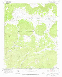
1970 Map of Valle San Antonio
USGS Topo · Published 1973About this map
Sulphur Springs and a series of geothermal Steam Wells define the western portion of this 1970s landscape, reflecting the unique volcanic geology of the region. This high-altitude terrain is dominated by the sprawling Baca Location No 1 land grant, which encompasses a sequence of sweeping mountain meadows including Valle San Antonio, Valle Seco, and Valle Santa Rosa. These open valleys are fed by a complex drainage system featuring San Antonio Creek and San Luis Creek, while the horizon is anchored by peaks like San Antonio Mountain and Cerro de la Garita. The map provides a detailed look at the land before it became more restrictive, showing various access points via Jeep Trails and the proximity to the Santa Fe National Forest and the Redondo Border.
Find a feature on this map
28 named features on this map. Tap any name to fly to it.
Don’t see what you’re looking for? This feature index may not catch every label — zoom into the map to look around manually.
Map Details
Editions of this 1970 Valle San Antonio Map
Other maps of this area

1890 · Jemes
USGS Topo · 1:125,000

1892 · Jemes
USGS Topo · 1:125,000

1892 · Santa Clara
USGS Topo · 1:125,000

1909 · Gallina
USGS Topo · 1:125,000

1918 · Abiquiu
USGS Topo · 1:125,000

1937 · Jemez Springs
USGS Topo · 1:48,000

1944 · Jemez Springs
USGS Topo · 1:62,500

1952 · Valle Toledo
USGS Topo · 1:24,000

1952 · Jemez Springs
USGS Topo · 1:62,500

1953 · Cerro Del Grant
USGS Topo · 1:24,000