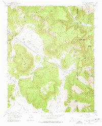
1952 Map of Valle Toledo
USGS Topo · Published 1977About this map
Baca Location No 1 dominates this high-altitude landscape, revealing the complex intersection of land grants and natural topography in Northern New Mexico. The terrain is defined by massive volcanic features including the Sierra de Toledo and the sprawling floor of the Valle Grande. Water drainage patterns are intricately mapped, showing the headwaters of San Antonio Creek and the East Fork Jemez River as they carve through the caldera. The map illustrates the administrative boundaries where the Santa Clara Indian Reservation meets the Santa Fe National Forest, a region primarily utilized for timber and grazing rather than dense settlement. Human presence is light, marked by remote outposts like Camp May and a lone Pipe Line traversing the mountain passes, reflecting the mid-century character of this isolated high-country domain.
Find a feature on this map
38 named features on this map. Tap any name to fly to it.
Don’t see what you’re looking for? This feature index may not catch every label — zoom into the map to look around manually.
Map Details
Editions of this 1952 Valle Toledo Map
5 editions found
Other maps of this area

1890 · Jemes
USGS Topo · 1:125,000

1892 · Jemes
USGS Topo · 1:125,000

1892 · Santa Clara
USGS Topo · 1:125,000

1909 · Gallina
USGS Topo · 1:125,000

1918 · Abiquiu
USGS Topo · 1:125,000

1937 · Jemez Springs
USGS Topo · 1:48,000

1944 · Jemez Springs
USGS Topo · 1:62,500

1952 · Valle Toledo
USGS Topo · 1:24,000

1952 · Jemez Springs
USGS Topo · 1:62,500

1952 · Frijoles
USGS Topo · 1:24,000