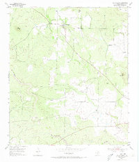
1955 Map of Valley Spring
USGS Topo · Published 1973About this map
Valley Spring and its surrounding ranchlands are depicted here during the mid-1950s, a period when the local economy relied heavily on groundwater management and cattle. Numerous windmills dot the terrain, marking the vital water sources required for livestock across the Llano County landscape. The settlement is anchored by the Valley Spring Cem and the Shiloh Ch, while the southern reaches of the quadrangle feature an inactive Quarry near Wolf Mountain, hinting at the area's geological extraction history.
Find a feature on this map
21 named features on this map. Tap any name to fly to it.
Don’t see what you’re looking for? This feature index may not catch every label — zoom into the map to look around manually.
Map Details
Editions of this 1955 Valley Spring Map
3 editions found
Other maps of this area

1887 · Llano
USGS Topo · 1:125,000

1894 · Llano
USGS Topo · 1:125,000

1904 · Llano
USGS Topo · 1:125,000

1909 · Llano
USGS Topo · 1:125,000

1918 · Llano
USGS Topo · 1:125,000

1954 · Llano
USGS Topo · 1:250,000

1955 · Llano
USGS Topo · 1:250,000
1955 · Magill Mountain
USGS Topo · 1:24,000

1955 · Valley Spring
USGS Topo · 1:24,000
1955 · Llano North
USGS Topo · 1:24,000