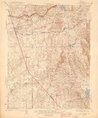
1944 Map of Valley Springs
USGS Topo · Published 1944About this map
The Mokelumne River and Calaveras River anchor this mid-century survey of the California gold country, capturing a landscape where water infrastructure and cattle ranching define the era. The Pardee Res dominates the northern reaches, while the Southern Pacific railroad line connects the settlements of Valley Springs and Wallace. The map reveals a high concentration of established family holdings, including the Stone Corral Ranch, Ospital Ranch, and Gaim Ranch, illustrating the agricultural character of Calaveras County prior to modern suburban expansion. Small community hubs like Jenny Lind and Lancha Plana appear alongside local institutions such as the Stone Corral Ch and Evergreen Sch. Evidence of the region’s mineral wealth persists at the McCarty Mine, situated amidst the complex drainage systems of Rich Gulch and South Gulch.
Find a feature on this map
47 named features on this map. Tap any name to fly to it.
Don’t see what you’re looking for? This feature index may not catch every label — zoom into the map to look around manually.
Map Details
Editions of this 1944 Valley Springs Map
4 editions found

Other maps of this area

1889 · Jackson
USGS Topo · 1:125,000

1892 · Jackson
USGS Topo · 1:125,000

1894 · Lodi
USGS Topo · 1:125,000

1897 · Jackson
USGS Topo · 1:125,000

1902 · Jackson
USGS Topo · 1:125,000

1908 · Linden
USGS Topo · 1:31,680

1909 · Goose Creek
USGS Topo · 1:31,680

1909 · Clements
USGS Topo · 1:31,680

1915 · Trigo
USGS Topo · 1:31,680

1915 · Peters
USGS Topo · 1:31,680