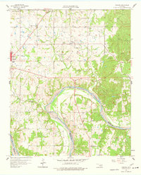
1958 Map of Vamoosa
USGS Topo · Published 1977About this map
Konawa Field and the surrounding petroleum landscape dominate this section of the Seminole Co and Pontotoc Co border during the late 1950s. The map illustrates a dense network of extraction infrastructure interspersed with rural institutions, notably the numerous family and community burial grounds such as Nash-Wood Cem, Wise Cem, and Moppin Cem. These sites, along with rural religious centers like Seminole Arkeba Ch and High Spring Ch, provide a detailed record of the mid-century social geography in this oil-producing region.
Find a feature on this map
34 named features on this map. Tap any name to fly to it.
Don’t see what you’re looking for? This feature index may not catch every label — zoom into the map to look around manually.
Map Details
Editions of this 1958 Vamoosa Map
4 editions found

Other maps of this area

1896 · Seminole and Prague
USGS Topo · 1:125,000

1901 · Stonewall
USGS Topo · 1:125,000

1907 · Maud
USGS Topo · 1:62,500

1908 · Maud
USGS Topo · 1:62,500

1954 · Oklahoma City
USGS Topo · 1:250,000

1957 · Ardmore
USGS Topo · 1:250,000

1957 · Oklahoma City
USGS Topo · 1:250,000

1958 · Sasakwa
USGS Topo · 1:24,000

1958 · Francis
USGS Topo · 1:24,000

1958 · Ada
USGS Topo · 1:24,000