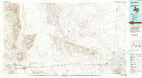
1985 Map of Van Horn
USGS Topo · Published 1993About this map
The high desert basins and isolated mountain ranges of West Texas define this 1985 landscape, anchored by the town of Van Horn. This critical crossroads is situated where the Southern Pacific railroad meets major transcontinental highways, serving as a gateway between the Sierra Diablo and the Wylie Mountains. The map reveals a land structured by water scarcity, marked by numerous named tanks and springs such as Sulphur Spring, Newman Spring, and the Leonore Reservoir.
Find a feature on this map
59 named features on this map. Tap any name to fly to it.
Don’t see what you’re looking for? This feature index may not catch every label — zoom into the map to look around manually.
Map Details
Editions of this 1985 Van Horn Map
3 editions found
Other maps of this area

1892 · Chispa
USGS Topo · 1:125,000

1894 · Valentine
USGS Topo · 1:125,000

1894 · Fort Davis
USGS Topo · 1:125,000

1895 · Chispa
USGS Topo · 1:125,000

1895 · Sierra Blanca
USGS Topo · 1:125,000

1897 · Valentine
USGS Topo · 1:125,000

1897 · Fort Davis
USGS Topo · 1:125,000

1897 · Eagle Mountain
USGS Topo · 1:125,000

1897 · Chispa
USGS Topo · 1:125,000

1906 · Van Horn
USGS Topo · 1:125,000