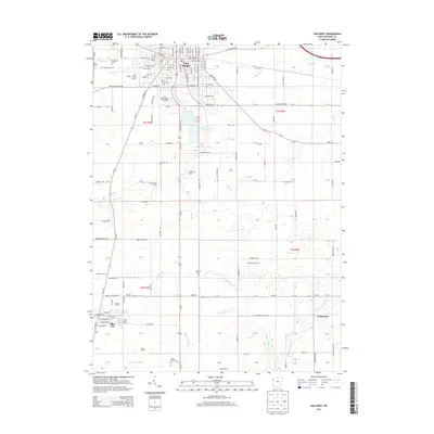
2013 Map of Van Wert
USGS Topo · Published 2013About this map
The city of Van Wert serves as the focal point of this 2013 topographic study, illustrating the grid of a developed county seat situated within the agricultural expanse of western Ohio. The map captures the infrastructure supporting the local economy, from the Van Wert County Airport and the Van Wert County Fairgrounds to the dual basins of Van Wert Reservoir Number One and Van Wert Reservoir Number Two. Beyond the urban limits, the landscape transitions into large-scale farming operations, including the named family lands of Matthews Farms, Hoffman Farms, and Breese Farms. The southern portion of the quadrangle shows the smaller communities of Ohio City and Jonestown, connected by a network of rural roads such as W Ervin Rd and the Lincoln Hwy. Several drainage systems, including Town Creek and the Little Auglaize River, carve through the township sections, while local history is preserved at Woodland Cemetery and Wallick Cemetery.
Find a feature on this map
72 named features on this map. Tap any name to fly to it.
Don’t see what you’re looking for? This feature index may not catch every label — zoom into the map to look around manually.
Map Details
Editions of this 2013 Van Wert Map
This is the sole edition of this map. No revisions or reprints were ever made.
Other maps of this area

1911 · Spencerville
USGS Topo · 1:62,500

1911 · Delphos
USGS Topo · 1:62,500

1914 · Celina
USGS Topo · 1:62,500

1914 · Van Wert
USGS Topo · 1:62,500

1944 · Delphos
USGS Topo · 1:62,500

1944 · Van Wert
USGS Topo · 1:62,500

1944 · Celina
USGS Topo · 1:62,500

1944 · Spencerville
USGS Topo · 1:62,500

1953 · Muncie
USGS Topo · 1:250,000

1956 · Muncie
USGS Topo · 1:250,000