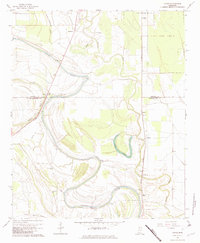
1967 Map of Vance
USGS Topo · Published 1982About this map
The alluvial landscape of the Mississippi Delta is defined here by the winding course of Cassidy Bayou, which meanders across the border of Quitman and Tallahatchie counties. This late-1960s survey illustrates a region shaped by agricultural drainage and rail transport, with the Illinois Central railroad corridor linking small settlements like Vance and Brazil. A notable ancient landmark, the Indian Mound, sits near Longstreet, while the northeast corner is occupied by a portion of the State Penal Farm Camp B.
Find a feature on this map
30 named features on this map. Tap any name to fly to it.
Don’t see what you’re looking for? This feature index may not catch every label — zoom into the map to look around manually.
Map Details
Editions of this 1967 Vance Map
3 editions found
Other maps of this area

1931 · Sumner
USGS Topo · 1:48,000

1932 · Philipp
USGS Topo · 1:48,000

1932 · Tutwiler
USGS Topo · 1:48,000

1935 · Crowder
USGS Topo · 1:62,500

1935 · Sumner
USGS Topo · 1:62,500

1935 · Tutwiler
USGS Topo · 1:62,500

1935 · Philipp
USGS Topo · 1:62,500

1939 · Sumner
USGS Topo · 1:62,500

1939 · Crowder
USGS Topo · 1:62,500

1939 · Philipp
USGS Topo · 1:62,500