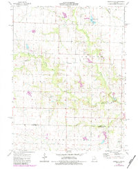
1973 Map of Vandalia Lake
USGS Topo · Published 1984About this map
Vandalia Lake and its surrounding Vandalia Community Lake recreational area anchor the northern portion of this landscape at the border of Linn and Cuivre townships. The map documents a rural agricultural region during the early 1970s, where small settlements like Rices Corner and landmarks such as the Lemasters Landing Strip reflect the local economy and transportation patterns. The land is drained by the West Fork Cuivre River and Hickory Creek, which wind through the terrain alongside local landmarks like a Claypit and a regional pipeline. Genealogists will find significant value in the documentation of several family and community burial sites, including New Providence Cem, Edwards Cem, and Fike Cem. Historic local congregations are also represented by the Mt Olivet Ch and West Cuivre Ch, situated near the crossing of the Audrain and Montgomery County line.
Find a feature on this map
21 named features on this map. Tap any name to fly to it.
Don’t see what you’re looking for? This feature index may not catch every label — zoom into the map to look around manually.
Map Details
Editions of this 1973 Vandalia Lake Map
2 editions found
Other maps of this area

1890 · Louisiana
USGS Topo · 1:125,000

1890 · Mexico
USGS Topo · 1:125,000

1942 · Wellsville
USGS Topo · 1:62,500

1942 · Bellflower
USGS Topo · 1:62,500

1943 · Vandalia
USGS Topo · 1:62,500

1945 · Bellflower
USGS Topo · 1:62,500

1945 · Perry
USGS Topo · 1:62,500

1945 · Vandalia
USGS Topo · 1:62,500

1948 · Quincy
USGS Topo · 1:250,000

1956 · Quincy
USGS Topo · 1:250,000