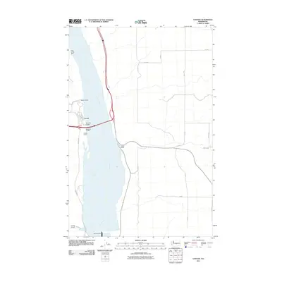
2011 Map of Vantage
USGS Topo · Published 2011About this map
The settlement of Vantage serves as a central hub on the western bank of the Columbia River, where Interstate 90 crosses this major waterway. This 2011 survey illustrates the modern transportation and energy infrastructure that defines the region, including the Vantage Airport and the significant Wanapum Dam to the south. The landscape is characterized by its distinct geological depressions and watercourses, such as Rocky Coulee, Schnebly Coulee, and Ryegrass Coulee, which cut through the high ground above the river. To the north, the topographic feature known as Hole in the Wall stands out along the river's edge. The map also traces a network of rural roads east of the river, including Road 11 SW and Road 12 SW, which serve the higher plateaus and drainages like Sand Hollow.
Find a feature on this map
27 named features on this map. Tap any name to fly to it.
Don’t see what you’re looking for? This feature index may not catch every label — zoom into the map to look around manually.
Map Details
Editions of this 2011 Vantage Map
This is the sole edition of this map. No revisions or reprints were ever made.
Other maps of this area

1909 · Quincy
USGS Topo · 1:62,500

1910 · Quincy
USGS Topo · 1:62,500

1912 · Beverly
USGS Topo · 1:62,500

1920 · Colockum Pass
USGS Topo · 1:125,000

1922 · Colockum Pass
USGS Topo · 1:125,000

1939 · Boylston
USGS Topo · 1:48,000

1943 · Boylston
USGS Topo · 1:62,500

1950 · Yakima
USGS Topo · 1:250,000

1953 · Ginkgo
USGS Topo · 1:24,000
1953 · Doris
USGS Topo · 1:24,000