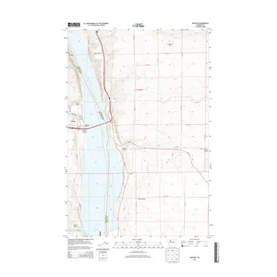
2013 Map of Vantage
USGS Topo · Published 2013About this map
The settlement of Vantage sits at a critical crossing of the Columbia River, where Interstate 90 bridges the water between Kittitas and Grant counties. This 2013 survey illustrates the dramatic geological transition from the riverbanks to the high plateau, dominated by the Frenchman Hills and the sprawling Babcock Bench. The landscape is defined by its arid drainage patterns, with numerous erosional features such as Rocky Coulee, Schnebly Coulee, and Ryegrass Coulee cutting toward the reservoir at Wanapum Lake. To the south, Sand Hollow and Middle Canyon mark the breaks in the terrain. While the town itself remains concentrated near the waterfront on Vantage Hwy and Lakeview Ave, the eastern side of the river is a network of rural routes, including 7-SW Rd and Road 10 SW, servicing the high-elevation benches and agricultural divisions of the plateau.
Find a feature on this map
32 named features on this map. Tap any name to fly to it.
Don’t see what you’re looking for? This feature index may not catch every label — zoom into the map to look around manually.
Map Details
Editions of this 2013 Vantage Map
This is the sole edition of this map. No revisions or reprints were ever made.
Other maps of this area

1909 · Quincy
USGS Topo · 1:62,500

1910 · Quincy
USGS Topo · 1:62,500

1912 · Beverly
USGS Topo · 1:62,500

1920 · Colockum Pass
USGS Topo · 1:125,000

1922 · Colockum Pass
USGS Topo · 1:125,000

1939 · Boylston
USGS Topo · 1:48,000

1943 · Boylston
USGS Topo · 1:62,500

1950 · Yakima
USGS Topo · 1:250,000

1953 · Ginkgo
USGS Topo · 1:24,000
1953 · Doris
USGS Topo · 1:24,000