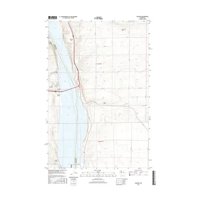
2017 Map of Vantage
USGS Topo · Published 2017About this map
Vantage sits along the western bank of the Columbia River in a landscape shaped by dramatic basalt formations and steep coulees. This 2017 survey shows the settlement overlooking Wanapum Lake, a reservoir created by the downstream Wanapum Dam. The topography is defined by the high, flat stretch of Babcock Bench and the prominent Frenchman Hills to the northeast. Notable geological features like Hole in the Wall and several dry erosional channels, including Schnebly Coulee, Ryegrass Coulee, and Rocky Coulee, illustrate the unique scabland terrain. Further south, Sand Hollow and Middle Canyon mark the breaks in the elevation as the land descends toward the river, highlighting the interaction between modern infrastructure and the ancient volcanic geology of Kittitas and Grant counties.
Find a feature on this map
31 named features on this map. Tap any name to fly to it.
Don’t see what you’re looking for? This feature index may not catch every label — zoom into the map to look around manually.
Map Details
Editions of this 2017 Vantage Map
This is the sole edition of this map. No revisions or reprints were ever made.
Other maps of this area

1909 · Quincy
USGS Topo · 1:62,500

1910 · Quincy
USGS Topo · 1:62,500

1912 · Beverly
USGS Topo · 1:62,500

1920 · Colockum Pass
USGS Topo · 1:125,000

1922 · Colockum Pass
USGS Topo · 1:125,000

1939 · Boylston
USGS Topo · 1:48,000

1943 · Boylston
USGS Topo · 1:62,500

1950 · Yakima
USGS Topo · 1:250,000

1953 · Ginkgo
USGS Topo · 1:24,000
1953 · Doris
USGS Topo · 1:24,000