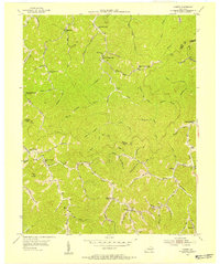
1954 Map of Varney
USGS Topo · Published 1955About this map
Varney serves as a central hub in this mid-century topographic survey of the hills along the Pike County and Martin County line. The landscape is defined by an intricate network of hollows and forks, where local life was organized around small schoolhouses and country churches. Educational landmarks like Pauley Sch and Hurricane on Brushy Sch are found tucked into the branching drainages of the Big Creek and Brushy Fork watersheds. The mapping reflects a settlement pattern typical of the Cumberland Plateau, with homes and community buildings following the narrow valley floors beneath heights such as Flag Knob. Notable spiritual sites including Apple Orchard Ch and Dunkard Ch provide specific points of interest for genealogists tracing family locations in this coal-rich region of Eastern Kentucky.
Find a feature on this map
78 named features on this map. Tap any name to fly to it.
Don’t see what you’re looking for? This feature index may not catch every label — zoom into the map to look around manually.
Map Details
Editions of this 1954 Varney Map
Other maps of this area

1886 · Prestonsburg
USGS Topo · 1:125,000

1887 · Warfield
USGS Topo · 1:125,000

1891 · Warfield
USGS Topo · 1:125,000

1892 · Prestonsburg
USGS Topo · 1:125,000

1910 · Naugatuck
USGS Topo · 1:48,000

1912 · Naugatuck
USGS Topo · 1:62,500

1914 · Laynesville
USGS Topo · 1:48,000

1914 · Inez
USGS Topo · 1:48,000

1915 · Williamson
USGS Topo · 1:48,000

1915 · Naugatuck
USGS Topo · 1:48,000