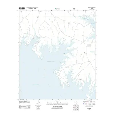
2011 Map of Veach
USGS Topo · Published 2011About this map
Sam Rayburn Reservoir dominates this East Texas landscape, where the waters of the Angelina River reach deep into the forested inlets of San Augustine County. The settlement of Veach sits inland from Veach Basin, surrounded by a complex network of creeks including Couchatana Creek, Lucas Creek, and Blackland Branch. This survey provides a precise look at the shoreline as it existed in the early 21st century, revealing how the reservoir has reshaped the local geography while leaving several community landmarks intact. For those tracing family histories in the Piney Woods, the map identifies several key burial grounds, including Lucas Cemetery, Williams Cemetery, New Hope Cemetery, and Coleman Cemetery. The High Point Lookout Tower remains a prominent navigational landmark overlooking the eastern ridges near Lane Creek and Norris Creek.
Find a feature on this map
29 named features on this map. Tap any name to fly to it.
Don’t see what you’re looking for? This feature index may not catch every label — zoom into the map to look around manually.
Map Details
Editions of this 2011 Veach Map
This is the sole edition of this map. No revisions or reprints were ever made.
Other maps of this area

1931 · Zavalla
USGS Topo · 1:62,500

1953 · Palestine
USGS Topo · 1:250,000

1957 · Palestine
USGS Topo · 1:250,000

1958 · Zavalla
USGS Topo · 1:62,500

1958 · Broaddus
USGS Topo · 1:62,500

1958 · Mc Gee Bend
USGS Topo · 1:62,500

1958 · Bronson
USGS Topo · 1:62,500
1984 · Veach
USGS Topo · 1:24,000
1984 · McGee Bend
USGS Topo · 1:24,000
1984 · Harvey Creek
USGS Topo · 1:24,000