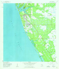
1944 Map of Venice
USGS Topo · Published 1961About this map
Venice Army Air Base dominates the mid-century coastline on this Sarasota County survey, reflecting the region's mobilization during World War II. The base is positioned just south of the main Venice townsite and the Municipal Airport, bordering the waters of the Gulf and Deerborn Gully. The transport network of the era is clearly defined by the Seaboard Air Line railroad, which services settlements from Laurel and Nokomis in the north down toward the timber and agricultural operations at Woodmere. Along the Manasota Peninsula, the landscape is a network of tidal inlets and creeks, including Dona Bay, Roberts Bay, and Alligator Creek. This 1940s topography shows the transition from early coastal hamlets like Manasota to a more structured inland grid at Venice Farms, all connected by the emerging corridor of Route 41.
Find a feature on this map
34 named features on this map. Tap any name to fly to it.
Don’t see what you’re looking for? This feature index may not catch every label — zoom into the map to look around manually.
Map Details
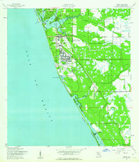
Editions of this 1944 Venice Map
3 editions found
Other maps of this area

1943 · Laurel
USGS Topo · 1:24,000

1944 · Bird Keys
USGS Topo · 1:31,680

1944 · Lower Myakka Lake
USGS Topo · 1:31,680

1944 · Myakka River
USGS Topo · 1:31,680

1944 · Laurel
USGS Topo · 1:31,680

1944 · Venice
USGS Topo · 1:31,680

1956 · Englewood
USGS Topo · 1:24,000

1956 · Tampa
USGS Topo · 1:250,000

1956 · Charlotte Harbor
USGS Topo · 1:250,000

1957 · Englewood NW
USGS Topo · 1:24,000