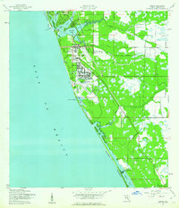
1944 Map of Venice
USGS Topo · Published 1961About this map
Venice Army Air Base dominates the southern portion of this mid-century coastal survey, reflecting the significant military footprint along the Gulf during the 1940s. The airfield, complete with a network of runways and a nearby Borrow Pit, is situated just inland from Red Lake and Horse and Chaise Point. The landscape is defined by the complex aquatic geography of the Manasota Peninsula, where Lemon Bay and Dona Bay meet the sea. Transportation is anchored by the Seaboard Air Line RR, which connects the established centers of Nokomis and Venice. Further south, the map documents smaller coastal settlements like Manasota and inland areas like Woodmere. The detailed mapping of various creeks, including Alligator Creek and Hatchett Creek, illustrates the natural drainage patterns that shaped early development in this part of Sarasota County.
Find a feature on this map
30 named features on this map. Tap any name to fly to it.
Don’t see what you’re looking for? This feature index may not catch every label — zoom into the map to look around manually.
Map Details
Editions of this 1944 Venice Map
3 editions found
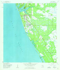
Other maps of this area

1943 · Laurel
USGS Topo · 1:24,000

1944 · Bird Keys
USGS Topo · 1:31,680

1944 · Lower Myakka Lake
USGS Topo · 1:31,680

1944 · Myakka River
USGS Topo · 1:31,680

1944 · Laurel
USGS Topo · 1:31,680

1944 · Venice
USGS Topo · 1:31,680

1956 · Englewood
USGS Topo · 1:24,000

1956 · Tampa
USGS Topo · 1:250,000

1956 · Charlotte Harbor
USGS Topo · 1:250,000

1957 · Englewood NW
USGS Topo · 1:24,000