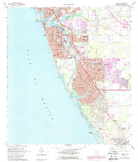
1973 Map of Venice
USGS Topo · Published 1987About this map
The Intracoastal Waterway and the Gulf coastline define the layout of Sarasota County in this mid-1970s record, capturing a period of significant residential expansion. Development is concentrated along the barrier islands of Casey Key and Lemon Key, while inland, the grid of Venice and its surrounding suburbs like Venice Gardens and South Venice fills the coastal plain. The Seaboard Coast Line railroad runs parallel to U S Highway 41, serving as a backbone for the region's transport network before the full modern density of the Suncoast was established.
Find a feature on this map
64 named features on this map. Tap any name to fly to it.
Don’t see what you’re looking for? This feature index may not catch every label — zoom into the map to look around manually.
Map Details
Editions of this 1973 Venice Map
3 editions found
Other maps of this area

1943 · Laurel
USGS Topo · 1:24,000

1944 · Bird Keys
USGS Topo · 1:31,680

1944 · Lower Myakka Lake
USGS Topo · 1:31,680

1944 · Myakka River
USGS Topo · 1:31,680

1944 · Laurel
USGS Topo · 1:31,680

1944 · Venice
USGS Topo · 1:31,680

1956 · Englewood
USGS Topo · 1:24,000

1956 · Tampa
USGS Topo · 1:250,000

1956 · Charlotte Harbor
USGS Topo · 1:250,000

1957 · Englewood NW
USGS Topo · 1:24,000