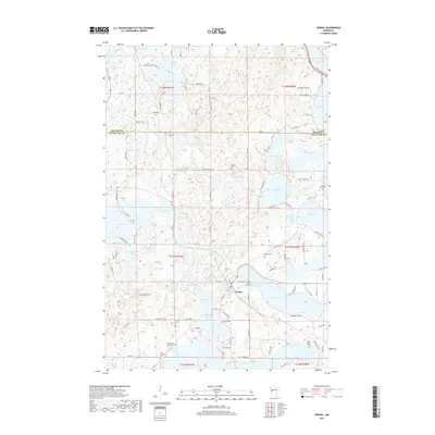
2019 Map of Vergas
USGS Topo · Published 2019About this map
Vergas sits at the heart of this lake-strewn landscape, where the town's grid meets the irregular shoreline of Long Lake. The area is defined by a dense concentration of glacial basins, ranging from the expansive waters of Eagle Lake and Lake Ida to smaller, secluded bodies like Happ Lake and Mike Lake. This 2019 survey reveals a mature recreational and rural residential pattern, with numerous private drives and access roads such as Wander Rd and Sybil Shores Dr encircling the water. Genealogists will find a significant number of burial sites documented across the countryside, including the Free Thought Cem, Saint Paul's Lutheran Cem, and the Schrams Cem near Schrams Lake. The map details the transition between township ranges, including t137n r41w and t138n r40w, showing how property lines and roads like 316th Ave navigate the complex topography created by these numerous interconnected waterways.
Find a feature on this map
130 named features on this map. Tap any name to fly to it.
Don’t see what you’re looking for? This feature index may not catch every label — zoom into the map to look around manually.
Map Details
Editions of this 2019 Vergas Map
This is the sole edition of this map. No revisions or reprints were ever made.
Other maps of this area

1912 · Vergas
USGS Topo · 1:62,500

1915 · Perham
USGS Topo · 1:62,500

1915 · Vergas
USGS Topo · 1:62,500

1953 · Brainerd
USGS Topo · 1:250,000

1957 · Brainerd
USGS Topo · 1:250,000

1958 · Brainerd
USGS Topo · 1:250,000

1959 · Rochert
USGS Topo · 1:24,000
1959 · Audubon
USGS Topo · 1:24,000
1959 · Detroit Lakes
USGS Topo · 1:24,000

1965 · Brainerd
USGS Topo · 1:250,000