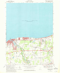
1969 Map of Vermilion East
USGS Topo · Published 1971About this map
Vermilion sits at the junction of the Vermilion River and the southern shore of Lake Erie, serving as a focal point for maritime activity and lakefront residential growth. The township of Brownhelm dominates the interior landscape, characterized by its transition from wooded parklands like Mill Hollow Bacon Woods Park to the emerging industrial and quarry zones near Amherst. The map documents a period of significant infrastructure development, with the Norfolk and Western and Penn Central railroads cutting across the terrain, alongside early segments of major highways planned to bypass the older village centers.
Find a feature on this map
74 named features on this map. Tap any name to fly to it.
Don’t see what you’re looking for? This feature index may not catch every label — zoom into the map to look around manually.
Map Details
Editions of this 1969 Vermilion East Map
Other maps of this area

1901 · Oberlin
USGS Topo · 1:62,500

1903 · Vermilion
USGS Topo · 1:62,500

1903 · Oberlin
USGS Topo · 1:62,500

1956 · Toledo
USGS Topo · 1:250,000

1959 · Berlin Heights
USGS Topo · 1:24,000

1959 · Vermilion East
USGS Topo · 1:24,000

1959 · Vermilion West
USGS Topo · 1:24,000

1959 · Kipton
USGS Topo · 1:24,000

1960 · Oberlin
USGS Topo · 1:24,000
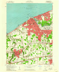
1960 · Lorain
USGS Topo · 1:24,000