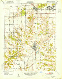
1948 Map of Vermont
USGS Topo · Published 1948About this map
The Camp Ellis Military Reservation dominates the northeastern corner of this western Illinois landscape, situated at the boundary of Farmers and Vermont townships. Established during the war years, this facility is shown alongside the established rail network of the Chicago Burlington and Quincy railroad, which connects the primary settlements of Vermont and Table Grove. This 1947 survey captures a transitional moment for the region, where a wartime military footprint sits adjacent to a traditional agricultural grid defined by the Fourth Principal Meridian.
Find a feature on this map
36 named features on this map. Tap any name to fly to it.
Don’t see what you’re looking for? This feature index may not catch every label — zoom into the map to look around manually.
Map Details
Editions of this 1948 Vermont Map
2 editions found
Other maps of this area

1912 · Macomb
USGS Topo · 1:62,500

1914 · Macomb
USGS Topo · 1:62,500

1918 · Vermont
USGS Topo · 1:62,500

1921 · Vermont
USGS Topo · 1:62,500

1923 · Rushville
USGS Topo · 1:62,500

1926 · Beardstown
USGS Topo · 1:62,500

1926 · Rushville
USGS Topo · 1:62,500

1944 · Beardstown
USGS Topo · 1:62,500

1947 · Vermont
USGS Topo · 1:24,000

1947 · Adair
USGS Topo · 1:24,000