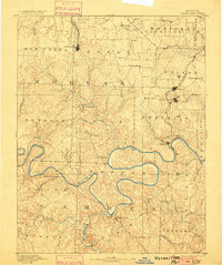
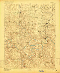
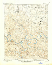
1893 Map of Versailles
USGS Topo · Published 1900About this map
Versailles stands as the primary rail terminus at the northern edge of this Ozark landscape, where the Missouri Pacific Railroad branches down to meet the rugged topography of the river basins. The central geography is dominated by the deep, winding meanders of the Osage River long before any modern impoundments transformed the valley. Along the river and its numerous tributaries, like Gravois Creek and Proctor Creek, small nineteenth-century communities such as Bagnell, Proctor, and Cape Galena mark the transition from agricultural uplands to the river-driven economy. A notable industrial presence is found at the Osage Iron Works near the southern bend of the river. To the south, the confluence with the Niangua River highlights the historic location of Linn Creek, which served as a vital regional hub. The map captures a complex network of township divisions like Haw Creek and Saline, illustrating the established social and political boundaries of central Missouri at the end of the century.
Find a feature on this map
65 named features on this map. Tap any name to fly to it.
Don’t see what you’re looking for? This feature index may not catch every label — zoom into the map to look around manually.
Map Details
Editions of this 1893 Versailles Map
4 editions found
Other maps of this area

1884 · Bolivar
USGS Topo · 1:125,000

1886 · Jefferson City
USGS Topo · 1:125,000

1887 · Sedalia
USGS Topo · 1:125,000

1887 · Warsaw
USGS Topo · 1:125,000

1888 · Versailles
USGS Topo · 1:125,000

1888 · Tuscumbia
USGS Topo · 1:125,000

1888 · Boonville
USGS Topo · 1:125,000

1892 · Bolivar
USGS Topo · 1:125,000

1893 · Versailles
USGS Topo · 1:125,000

1894 · Warsaw
USGS Topo · 1:125,000