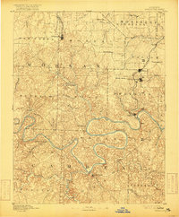
1893 Map of Versailles
USGS Topo · Published 1916About this map
The Osage River winds in deep, serpentine loops across this late nineteenth-century landscape, long before modern dams transformed the river valley. Central to the region's transport is the Missouri Pacific Railroad, which connects the county seat of Versailles to southern outposts like Bagnell. The terrain is defined by a dense network of drainages, including the Big Niangua River and Little Niangua River, which carve through the Ozark highlands to meet the Osage. This era shows a distributed economy of small mill and industrial sites, evidenced by Gravois Mills and the intriguing Osage Iron Works Creek. Small settlements like Aurora Springs and Linn Creek serve as local hubs for the surrounding townships, providing a clear look at the Missouri interior during a period of expanding rail infrastructure and riverside commerce.
Find a feature on this map
62 named features on this map. Tap any name to fly to it.
Don’t see what you’re looking for? This feature index may not catch every label — zoom into the map to look around manually.
Map Details
Editions of this 1893 Versailles Map
4 editions found
Other maps of this area

1884 · Bolivar
USGS Topo · 1:125,000

1886 · Jefferson City
USGS Topo · 1:125,000

1887 · Sedalia
USGS Topo · 1:125,000

1887 · Warsaw
USGS Topo · 1:125,000

1888 · Versailles
USGS Topo · 1:125,000

1888 · Tuscumbia
USGS Topo · 1:125,000

1888 · Boonville
USGS Topo · 1:125,000

1892 · Bolivar
USGS Topo · 1:125,000

1893 · Versailles
USGS Topo · 1:125,000

1894 · Warsaw
USGS Topo · 1:125,000