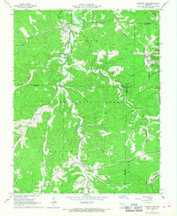
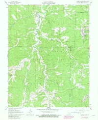
1967 Map of Viburnum West
USGS Topo · Published 1968About this map
Clark National Forest blankets this corner of the Ozarks, where the 1960s economy was defined by a combination of old timber tracts and emerging mineral extraction. The town of Viburnum sits on the eastern edge of the map, adjacent to industrial landmarks like the St Louis-San Francisco railroad and large Tailings Ponds that signal the region's lead mining operations. In the northwest, the settlement of Dillard serves as a local hub near Huzzah Creek, which winds through the landscape alongside an Old Railroad Grade. This survey captures a moment when traditional land uses began to shift, as evidenced by the Viburnum Landing Strip and the modern town grid. Genealogists will find several family-named burial sites across the wooded hollows, including Fiebelman Cem, Hedrick Cem, and Richards Cem.
Find a feature on this map
33 named features on this map. Tap any name to fly to it.
Don’t see what you’re looking for? This feature index may not catch every label — zoom into the map to look around manually.
Map Details
Editions of this 1967 Viburnum West Map
5 editions found
Other maps of this area

1932 · Steelville
USGS Topo · 1:48,000

1933 · Steelville
USGS Topo · 1:62,500

1937 · Steelville
USGS Topo · 1:62,500

1941 · Stone Hill
USGS Topo · 1:62,500

1943 · Berryman
USGS Topo · 1:62,500

1943 · Boss
USGS Topo · 1:62,500

1945 · Stone Hill
USGS Topo · 1:62,500

1945 · Berryman
USGS Topo · 1:62,500

1946 · Boss
USGS Topo · 1:62,500

1949 · Rolla
USGS Topo · 1:250,000