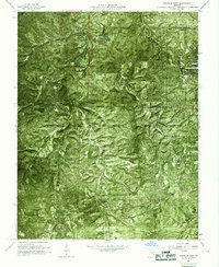
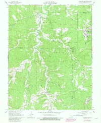
1967 Map of Viburnum West
USGS Topo · Published 1969About this map
Clark National Forest dominates the landscape of this late 1960s orthophotomap, where the rugged topography of the Ozarks is captured through aerial photography and topographic contouring. The settlement of Viburnum sits at the eastern edge of the sheet, adjacent to industrial features like a Tailings Pond and a Landing Strip, signaling the region's mid-century mining activity. To the northwest, the small community of Dillard is situated near the confluence of Huzzah Creek and its West Branch. The map reveals a complex network of hollows, including Possum Hollow and Bills Hollow, which drain into larger systems like Courtois Creek. Genealogists may find interest in several rural Cem sites located along the winding valley roads that connect these isolated settlements through the wooded terrain of Dent, Crawford, and Iron counties.
Find a feature on this map
21 named features on this map. Tap any name to fly to it.
Don’t see what you’re looking for? This feature index may not catch every label — zoom into the map to look around manually.
Map Details
Editions of this 1967 Viburnum West Map
5 editions found
Other maps of this area

1932 · Steelville
USGS Topo · 1:48,000

1933 · Steelville
USGS Topo · 1:62,500

1937 · Steelville
USGS Topo · 1:62,500

1941 · Stone Hill
USGS Topo · 1:62,500

1943 · Berryman
USGS Topo · 1:62,500

1943 · Boss
USGS Topo · 1:62,500

1945 · Stone Hill
USGS Topo · 1:62,500

1945 · Berryman
USGS Topo · 1:62,500

1946 · Boss
USGS Topo · 1:62,500

1949 · Rolla
USGS Topo · 1:250,000