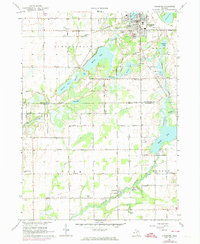
1967 Map of Vicksburg
USGS Topo · Published 1974About this map
The village of Vicksburg serves as the focal point of this Kalamazoo and St. Joseph County borderland, situated where Portage Creek flows through a series of significant water bodies including Sunset Lake and Barton Lake. The landscape is defined by its glacial hydrology, with Portage River winding southward toward Parkville and the expansive Portage Lake. Transportation and industry are well-represented by the Penn Central rail line and numerous Gravel Pits and Marl Pits that reflect the area's geological resources.
Find a feature on this map
54 named features on this map. Tap any name to fly to it.
Don’t see what you’re looking for? This feature index may not catch every label — zoom into the map to look around manually.
Map Details
Editions of this 1967 Vicksburg Map
3 editions found
Other maps of this area

1914 · Three Rivers
USGS Topo · 1:62,500

1916 · Three Rivers
USGS Topo · 1:62,500

1918 · Leonidas
USGS Topo · 1:62,500

1922 · Schoolcraft
USGS Topo · 1:62,500

1943 · Three Rivers
USGS Topo · 1:62,500

1943 · Schoolcraft
USGS Topo · 1:62,500

1944 · Leonidas
USGS Topo · 1:62,500

1947 · Leonidas
USGS Topo · 1:62,500

1950 · Leonidas
USGS Topo · 1:62,500

1953 · Fort Wayne
USGS Topo · 1:250,000