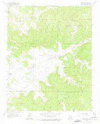
1963 Map of Vigas Canyon
USGS Topo · Published 1975About this map
The Carson National Forest landscape in Rio Arriba County is defined by a high-desert topography of mesas and deep drainage systems. This 1963 survey shows an area dominated by energy extraction and historical sites, centered on the Gas Field that spans much of the central canyon floor. The map records several Gas Wells and an Oil Well nestled among the winding walls of Cereza Canyon and Muñoz Canyon. Local water sources are vital markers in this arid environment, with Jaramillo Spring, Tecolote Spring, and the Candelaria Waterhole providing essential points of interest for historical study. The southern portion of the sheet is marked by the Jicarilla Apache Indian Reservation Boundary, while archaeological evidence of earlier inhabitants is noted at the Indian Ruins found near the Arroyo Compañero.
Find a feature on this map
24 named features on this map. Tap any name to fly to it.
Don’t see what you’re looking for? This feature index may not catch every label — zoom into the map to look around manually.
Map Details
Editions of this 1963 Vigas Canyon Map
3 editions found
Other maps of this area

1889 · Largo
USGS Topo · 1:250,000

1895 · Largo
USGS Topo · 1:250,000

1954 · Aztec
USGS Topo · 1:250,000

1958 · Aztec
USGS Topo · 1:250,000

1962 · Aztec
USGS Topo · 1:250,000

1963 · Lapis Point
USGS Topo · 1:24,000

1963 · Schmitz Ranch
USGS Topo · 1:24,000

1963 · Fourmile Canyon
USGS Topo · 1:24,000

1963 · Gobernador
USGS Topo · 1:24,000

1963 · Gonzales Mesa
USGS Topo · 1:24,000