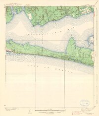
1938 Map of Villa Tasso
USGS Topo · Published 1938About this map
The northern shores of Choctawhatchee Bay are dominated by the Choctawhatchee National Forest in this pre-war survey, where small settlements like Villa Tasso and Bolton sit at the edge of the timber. To the west, the growing town of Valparaiso is established between Boggy Bayou and Rocky Bayou, indicating early regional development. The landscape is defined by its intricate shoreline, featuring points such as Buccaroo Pt and White Pt that reach into the bay.
Find a feature on this map
41 named features on this map. Tap any name to fly to it.
Don’t see what you’re looking for? This feature index may not catch every label — zoom into the map to look around manually.
Map Details
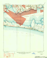
Editions of this 1938 Villa Tasso Map
4 editions found

Other maps of this area

1934 · Holt
USGS Topo · 1:48,000

1934 · Niceville
USGS Topo · 1:48,000

1935 · Villa Tasso
USGS Topo · 1:48,000

1935 · De Funiak Springs
USGS Topo · 1:48,000

1936 · Niceville
USGS Topo · 1:62,500

1936 · Point Washington
USGS Topo · 1:48,000

1937 · Holt
USGS Topo · 1:62,500

1938 · Mary Esther
USGS Topo · 1:62,500

1938 · Villa Tasso
USGS Topo · 1:62,500

1938 · De Funiak Springs
USGS Topo · 1:62,500