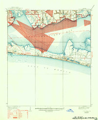
1938 Map of Villa Tasso
USGS Topo · Published 1944About this map
Eglin Air Force Base and the Moreno Point Military Reservation dominate this coastal landscape, illustrating the significant military footprint on the Florida Panhandle during the late 1930s and early 1940s. The map highlights restricted zones for all navigation within Choctawhatchee Bay and features specialized facilities like the Line of Fire Laboratory. Away from the military zones, the area maintains a sparse coastal character with small settlements such as Villa Tasso and Bolton situated near the dense network of inlets, including Boggy Bayou and Rocky Bayou.
Find a feature on this map
42 named features on this map. Tap any name to fly to it.
Don’t see what you’re looking for? This feature index may not catch every label — zoom into the map to look around manually.
Map Details
Editions of this 1938 Villa Tasso Map
4 editions found

Other maps of this area

1934 · Holt
USGS Topo · 1:48,000

1934 · Niceville
USGS Topo · 1:48,000

1935 · Villa Tasso
USGS Topo · 1:48,000

1935 · De Funiak Springs
USGS Topo · 1:48,000

1936 · Niceville
USGS Topo · 1:62,500

1936 · Point Washington
USGS Topo · 1:48,000

1937 · Holt
USGS Topo · 1:62,500

1938 · Mary Esther
USGS Topo · 1:62,500

1938 · Villa Tasso
USGS Topo · 1:62,500

1938 · De Funiak Springs
USGS Topo · 1:62,500