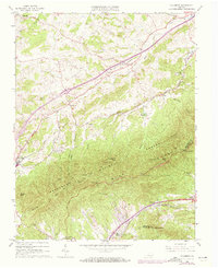
1963 Map of Villamont
USGS Topo · Published 1973About this map
Fincastle and Troutville anchor this 1963 survey of the Virginia highlands, where the Norfolk and Western railway snakes through the narrow valleys of Botetourt County. The landscape is defined by the sharp rise of the Blue Ridge, with the Appalachian Trail following the high ground past Grindstone Knob and Blue Knob. Evidence of local industry and community life appears in the Spec Mines and a network of rural meeting places like Camp Bethel and New Bethel Church.
Find a feature on this map
52 named features on this map. Tap any name to fly to it.
Don’t see what you’re looking for? This feature index may not catch every label — zoom into the map to look around manually.
Map Details
Editions of this 1963 Villamont Map
4 editions found
Other maps of this area

1890 · Roanoke
USGS Topo · 1:125,000

1891 · Roanoke
USGS Topo · 1:125,000

1894 · Natural Bridge
USGS Topo · 1:125,000

1894 · Natural Bridge
USGS Topo · 1:62,500

1907 · Natural Bridge Special
USGS Topo · 1:62,500

1913 · Eagle Rock
USGS Topo · 1:48,000

1915 · Eagle Rock
USGS Topo · 1:62,500

1929 · Roanoke
USGS Topo · 1:48,000

1933 · Roanoke
USGS Topo · 1:62,500

1947 · Roanoke
USGS Topo · 1:250,000