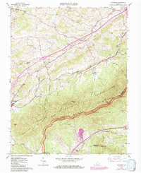
1963 Map of Villamont
USGS Topo · Published 1985About this map
Fincastle and Troutville anchor the northern and western reaches of this Botetourt County landscape, where the valley floor meets the rising peaks of the Jefferson National Forest. The 1960s era shown here captures a transition as newer corridors like the Blue Ridge Parkway and modern interchanges overlie older pathways. Industrial and community history is visible in the presence of Spec Mines and the Norfolk and Western railway, which skirts the base of the ridge. Genealogy researchers can locate family landmarks such as Booze Cem, Simmons Cem, and Thompson Cems. Significant local institutions including Gravel Hill Ch and a Prison Camp near the Stony Creek drainage provide a view of the social infrastructure of the mid-20th century. High points like Grindstone Knob and Fullhart Knob dominate the terrain, offering a geographic context for the small settlements of Nace and Lithia.
Find a feature on this map
52 named features on this map. Tap any name to fly to it.
Don’t see what you’re looking for? This feature index may not catch every label — zoom into the map to look around manually.
Map Details
Editions of this 1963 Villamont Map
4 editions found
Other maps of this area

1890 · Roanoke
USGS Topo · 1:125,000

1891 · Roanoke
USGS Topo · 1:125,000

1894 · Natural Bridge
USGS Topo · 1:125,000

1894 · Natural Bridge
USGS Topo · 1:62,500

1907 · Natural Bridge Special
USGS Topo · 1:62,500

1913 · Eagle Rock
USGS Topo · 1:48,000

1915 · Eagle Rock
USGS Topo · 1:62,500

1929 · Roanoke
USGS Topo · 1:48,000

1933 · Roanoke
USGS Topo · 1:62,500

1947 · Roanoke
USGS Topo · 1:250,000