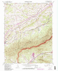
1963 Map of Villamont
USGS Topo · Published 1985About this map
Spec Mines and the Norfolk and Western railroad corridor define the industrial and transit landscape of this 1963 survey of Botetourt County, revised in the early 1980s. The terrain is marked by family-named landmarks and historical sites, including the Booze Cem, Simmons Cem, and Thompson Cem. The Jefferson National Forest dominates the southern half of the map, where the Appalachian Trail snakes through high points like Fullhart Knob and Flattop. Evidence of civic and social infrastructure is found at the Prison Camp near Troutville and Camp Bethel along Spring Creek. Small communities such as Nace and Villamont sit along the rail line, while the Blue Ridge Parkway traces the mountain crest, offering vistas at Great Valley Overlook.
Find a feature on this map
54 named features on this map. Tap any name to fly to it.
Don’t see what you’re looking for? This feature index may not catch every label — zoom into the map to look around manually.
Map Details
Editions of this 1963 Villamont Map
4 editions found
Other maps of this area

1890 · Roanoke
USGS Topo · 1:125,000

1891 · Roanoke
USGS Topo · 1:125,000

1894 · Natural Bridge
USGS Topo · 1:125,000

1894 · Natural Bridge
USGS Topo · 1:62,500

1907 · Natural Bridge Special
USGS Topo · 1:62,500

1913 · Eagle Rock
USGS Topo · 1:48,000

1915 · Eagle Rock
USGS Topo · 1:62,500

1929 · Roanoke
USGS Topo · 1:48,000

1933 · Roanoke
USGS Topo · 1:62,500

1947 · Roanoke
USGS Topo · 1:250,000