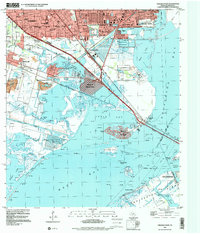
1995 Map of Virginia Point
USGS Topo · Published 2000About this map
The industrial waterfront of Texas City and the expanding residential finger-islands of the Gulf Coast define this mid-1990s landscape. Heavy industry around the Turning Basin and Industrial Canal stands in stark contrast to the intricate wetlands of Jones Bay and West Bay. The map highlights the unique residential development of the Village of Tiki Island and the Village of Bayou Vista, where dredged canals created high-density waterfront living along the Intracostal Waterway. Inland, the established communities of La Marque and Hitchcock are detailed with their essential civic institutions, including La Marque Cem and Queen of Peace Ch. This era of mapping documents the complex management of the Texas shoreline, evidenced by the Highland Bayou Diversion Canal and the extensive Galveston and Texas City Causeway connecting the mainland to Galveston Island.
Find a feature on this map
58 named features on this map. Tap any name to fly to it.
Don’t see what you’re looking for? This feature index may not catch every label — zoom into the map to look around manually.
Map Details
Editions of this 1995 Virginia Point Map
This is the sole edition of this map. No revisions or reprints were ever made.
Other maps of this area

1929 · Dickinson
USGS Topo · 1:24,000

1929 · Karankawa Lake
USGS Topo · 1:24,000

1929 · Hitchcock
USGS Topo · 1:24,000

1929 · Virginia Point
USGS Topo · 1:24,000

1929 · Texas City
USGS Topo · 1:24,000

1930 · Galveston
USGS Topo · 1:24,000

1931 · Lake Como
USGS Topo · 1:24,000

1932 · Dickinson
USGS Topo · 1:31,680

1932 · Texas City
USGS Topo · 1:31,680

1932 · Bolivar Point
USGS Topo · 1:24,000