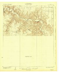
1932 Map of Vivian
USGS Topo · Published 1932About this map
The Pease River carves a deeply incised path across this Northwest Texas landscape, defining a rugged boundary zone between Cottle, Hardeman, and Foard counties. This 1932 edition, based on surveys from the mid-1920s, shows a transitional stage of mapping where large swaths are identified as Preliminary Edition Unsurveyed Area. The topography is dominated by the complex drainage systems of Haystack Creek and Raggedy Creek, which feed into the primary river valley from the south. In the more settled northeast corner, the presence of the Forestburg Sch suggests a rural community hub situated on the higher plateau above the breaks. This map captures the stark environmental contrast between the flat, cultivable uplands and the eroded, broken terrain of the river breaks during the early twentieth century.
Find a feature on this map
8 named features on this map. Tap any name to fly to it.
Don’t see what you’re looking for? This feature index may not catch every label — zoom into the map to look around manually.
Map Details
Editions of this 1932 Vivian Map
2 editions found
Other maps of this area

1927 · Quanah 3-a
USGS Topo · 1:48,000

1927 · Quanah 3-b
USGS Topo · 1:48,000

1932 · Vivian
USGS Topo · 1:62,500

1954 · Lubbock
USGS Topo · 1:250,000

1954 · Plainview
USGS Topo · 1:250,000

1954 · Wichita Falls
USGS Topo · 1:250,000

1955 · Lawton
USGS Topo · 1:250,000

1958 · Wichita Falls
USGS Topo · 1:250,000

1958 · Plainview
USGS Topo · 1:250,000

1958 · Medicine Mound
USGS Topo · 1:62,500