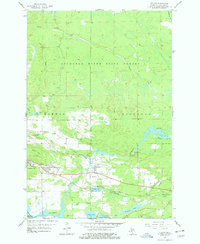
1955 Map of Vulcan
USGS Topo · Published 1978About this map
Industrial extraction and deep woodland define this landscape in the mid-1950s, where the iron mining heritage of the Menominee Range is etched into the terrain. The community of Vulcan and nearby Loretto serve as hubs for the surrounding labor, flanked by the Loretto Mine and Appleton Mine. Large Mine Dumps near Brier Hill signify the scale of subsurface activity that drove the local economy. Heavy rail infrastructure, specifically the Chicago and North Western line, cuts through the river valleys to transport ore out of the region.
Find a feature on this map
30 named features on this map. Tap any name to fly to it.
Don’t see what you’re looking for? This feature index may not catch every label — zoom into the map to look around manually.
Map Details
Editions of this 1955 Vulcan Map
2 editions found
Other maps of this area

1939 · Pembine
USGS Topo · 1:48,000

1947 · Pembine
USGS Topo · 1:48,000

1954 · Escanaba
USGS Topo · 1:250,000

1955 · Norway
USGS Topo · 1:24,000

1955 · Vulcan
USGS Topo · 1:24,000

1955 · Norway
USGS Topo · 1:62,500

1956 · Foster City
USGS Topo · 1:62,500

1957 · Escanaba
USGS Topo · 1:250,000

1958 · Escanaba
USGS Topo · 1:250,000

1963 · Pembine
USGS Topo · 1:62,500