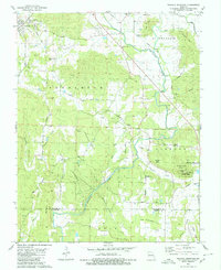
1980 Map of Wachita Mountain
USGS Topo · Published 1980About this map
The settlement of Doe Run and the surrounding highlands of the St. Francois Mountains define this 1980 survey. The landscape is a patchwork of industrial history and protected wilderness, where several quarries and a Mine Dump at the northern edge contrast with the Mark Twain National Forest and the Wachita Mountain Campground to the south. The mapping of the St. Francis River as it winds past Syenite reveals the region's complex drainage, fed by numerous creeks such as Polecat Creek and Wildcat Hollow.
Find a feature on this map
52 named features on this map. Tap any name to fly to it.
Don’t see what you’re looking for? This feature index may not catch every label — zoom into the map to look around manually.
Map Details
Editions of this 1980 Wachita Mountain Map
2 editions found
Other maps of this area

1904 · Farmington
USGS Topo · 1:62,500

1905 · Bonneterre
USGS Topo · 1:62,500

1906 · Farmington
USGS Topo · 1:62,500

1937 · Ironton
USGS Topo · 1:48,000

1939 · Fredericktown
USGS Topo · 1:48,000

1945 · Ironton
USGS Topo · 1:62,500

1946 · Ironton
USGS Topo · 1:62,500

1947 · Fredericktown
USGS Topo · 1:62,500

1949 · Rolla
USGS Topo · 1:250,000

1950 · Fredericktown
USGS Topo · 1:62,500