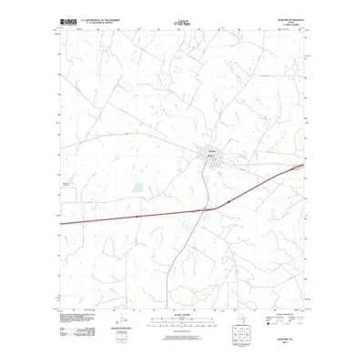
2010 Map of Waelder
USGS Topo · Published 2010About this map
Waelder sits at the heart of this Gonzales County landscape, where the local street grid is defined by A Ave and H Ave. The area is characterized by a dense network of watercourses that drain the surrounding plains, including the long reaches of Baldridge Creek and Boggy Creek. A notable alternative spelling of the primary settlement appears as Welder, reflecting the phonetic history of the local nomenclature. Outside the town center, the land is etched with numerous rural routes such as Sparta Field Rd and FM 1296, connecting outlying farms and ranchlands. To the west, the Janecka Lake Dam provides a localized water control point along the drainage basin that feeds into the Sandy Fork. This 2010 survey illustrates the modern road network, including the high-speed transit corridor that bypasses the historic town center, while numerous smaller streams like Pecan Creek and Reed Branch continue to define the original property boundaries and topography.
Find a feature on this map
40 named features on this map. Tap any name to fly to it.
Don’t see what you’re looking for? This feature index may not catch every label — zoom into the map to look around manually.
Map Details
Editions of this 2010 Waelder Map
This is the sole edition of this map. No revisions or reprints were ever made.
Other maps of this area

1901 · Flatonia
USGS Topo · 1:125,000

1953 · Seguin
USGS Topo · 1:250,000

1958 · Seguin
USGS Topo · 1:250,000

1962 · Dilworth
USGS Topo · 1:24,000
1962 · Gonzales North
USGS Topo · 1:24,000
1964 · Delhi
USGS Topo · 1:24,000
1964 · Sandy Fork
USGS Topo · 1:24,000

1964 · Waelder
USGS Topo · 1:24,000

1964 · Jeddo
USGS Topo · 1:24,000

1965 · Cistern
USGS Topo · 1:24,000