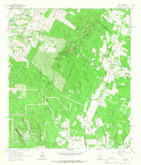
1964 Map of Delhi
USGS Topo · Published 1966About this map
Delhi and its rural surrounds at the mid-1960s are defined by the convergence of several major drainage systems and county boundaries. The settlement itself is anchored by the Delhi Ch and the adjacent Delhi Cem, serving as a social and genealogical hub for the surrounding countryside. The landscape is deeply incised by watercourses, including Sandy Fork, Tenney Creek, and Campbell Creek, which shape the local topography into distinct features like Devil Hollow and Chalk Hollow. This 1964 survey captures a moment when the rural character of Caldwell County remained largely agricultural and dispersed.
Find a feature on this map
14 named features on this map. Tap any name to fly to it.
Don’t see what you’re looking for? This feature index may not catch every label — zoom into the map to look around manually.
Map Details
Editions of this 1964 Delhi Map
2 editions found
Other maps of this area

1901 · Flatonia
USGS Topo · 1:125,000

1911 · San Marcos
USGS Topo · 1:125,000

1919 · San Marcos
USGS Topo · 1:125,000

1925 · San Marcos 1-d
USGS Topo · 1:48,000

1925 · San Marcos 4-a
USGS Topo · 1:48,000

1929 · Luling
USGS Topo · 1:62,500

1930 · Lockhart
USGS Topo · 1:62,500

1953 · Seguin
USGS Topo · 1:250,000

1958 · Seguin
USGS Topo · 1:250,000
1963 · McMahan
USGS Topo · 1:24,000