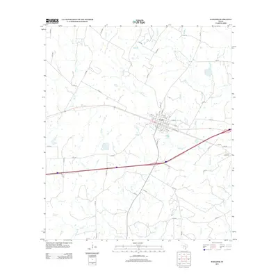
2013 Map of Waelder
USGS Topo · Published 2013About this map
The town of Waelder serves as the focal point of this South Texas landscape, where a dense network of county roads radiates through the surrounding ranch and farmland. Situated in the early 21st century, the map illustrates the local infrastructure and the natural drainage systems that define this part of Gonzales County. Numerous tributaries, including Baldridge Cr and Copperas Cr, wind through the terrain, eventually feeding into Sandy Fork. To the southeast, the Andrews Chapel Cem provides a specific point of interest for genealogists and local historians, sitting near the intersection of several rural routes like Co RD 415. The layout of Waelder itself is well-defined, showing the residential street grid and its relationship to the regional transportation corridors that cross the area.
Find a feature on this map
67 named features on this map. Tap any name to fly to it.
Don’t see what you’re looking for? This feature index may not catch every label — zoom into the map to look around manually.
Map Details
Editions of this 2013 Waelder Map
This is the sole edition of this map. No revisions or reprints were ever made.
Other maps of this area

1901 · Flatonia
USGS Topo · 1:125,000

1953 · Seguin
USGS Topo · 1:250,000

1958 · Seguin
USGS Topo · 1:250,000

1962 · Dilworth
USGS Topo · 1:24,000
1962 · Gonzales North
USGS Topo · 1:24,000
1964 · Delhi
USGS Topo · 1:24,000
1964 · Sandy Fork
USGS Topo · 1:24,000

1964 · Waelder
USGS Topo · 1:24,000

1964 · Jeddo
USGS Topo · 1:24,000

1965 · Cistern
USGS Topo · 1:24,000