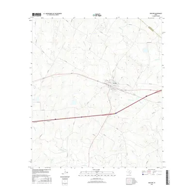
2016 Map of Waelder
USGS Topo · Published 2016About this map
The town of Waelder serves as a central hub in this section of the Texas coastal plains, situated along the county line between Fayette Co and Gonzales Co. The landscape is defined by a dense network of tributaries feeding into the Sandy Fork, including Pecan Cr, Baldridge Cr, and Boggy Cr. These watercourses create a distinct drainage pattern across the region's undulating elevation. The grid of Waelder is clearly delineated, showing established corridors like N Railroad St and Ralph Bunche St that reflect the town's historical development alongside transport lines. To the northwest, the isolated Jenecko Lake provides a notable landmark amidst a terrain dominated by rural county roads and creek crossings such as Reed Br and Bee Br.
Find a feature on this map
61 named features on this map. Tap any name to fly to it.
Don’t see what you’re looking for? This feature index may not catch every label — zoom into the map to look around manually.
Map Details
Editions of this 2016 Waelder Map
This is the sole edition of this map. No revisions or reprints were ever made.
Other maps of this area

1901 · Flatonia
USGS Topo · 1:125,000

1953 · Seguin
USGS Topo · 1:250,000

1958 · Seguin
USGS Topo · 1:250,000

1962 · Dilworth
USGS Topo · 1:24,000
1962 · Gonzales North
USGS Topo · 1:24,000
1964 · Delhi
USGS Topo · 1:24,000
1964 · Sandy Fork
USGS Topo · 1:24,000

1964 · Waelder
USGS Topo · 1:24,000

1964 · Jeddo
USGS Topo · 1:24,000

1965 · Cistern
USGS Topo · 1:24,000