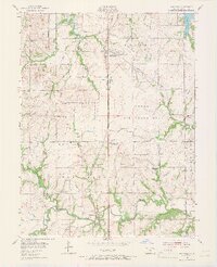
1955 Map of Wakarusa
USGS Topo · Published 1966About this map
Forbes Air Force Base dominates the central landscape south of Topeka, serving as a massive military installation that defines the mid-century geography of Shawnee County. This Cold War era survey captures the base alongside a network of rural schoolhouses and cemeteries that reveal the transition of the Kansas prairie. Several schoolhouses, including Williamsport Sch and Harrison Sch, are already noted as abandoned, marking the consolidation of rural education districts.
Find a feature on this map
36 named features on this map. Tap any name to fly to it.
Don’t see what you’re looking for? This feature index may not catch every label — zoom into the map to look around manually.
Map Details
Editions of this 1955 Wakarusa Map
4 editions found
Other maps of this area

1889 · Burlingame
USGS Topo · 1:125,000

1889 · Topeka
USGS Topo · 1:125,000

1894 · Burlingame
USGS Topo · 1:125,000

1894 · Topeka
USGS Topo · 1:125,000

1947 · Lawrence
USGS Topo · 1:250,000

1950 · Kansas City
USGS Topo · 1:250,000

1950 · Lawrence
USGS Topo · 1:250,000

1950 · Topeka
USGS Topo · 1:24,000

1950 · Grantville
USGS Topo · 1:24,000

1951 · Grantville
USGS Topo · 1:24,000