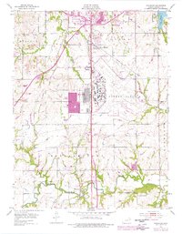
1955 Map of Wakarusa
USGS Topo · Published 1976About this map
The Forbes Field military installation and its associated airfield dominate the landscape south of Topeka, illustrating the intersection of Cold War-era aviation and Kansas prairie. The expansion of residential areas is visible through purple-tinted revisions, showing growth in Cullen Village and developments near Pauline. Outside the urbanizing core, the land maintains a rural character defined by the winding Wakarusa River and numerous family-named burial grounds like Foster Cem and Yocum Cem. To the northwest, the Potawatomi Indian Reservation Boundary marks a significant historical jurisdictional line. Transportation networks are deeply integrated into the terrain, from the Kansas Toll Road to the tracks of the Atchison Topeka and Santa Fe railroad, which parallels the river and serves the smaller settlement of Wakarusa.
Find a feature on this map
41 named features on this map. Tap any name to fly to it.
Don’t see what you’re looking for? This feature index may not catch every label — zoom into the map to look around manually.
Map Details
Editions of this 1955 Wakarusa Map
4 editions found
Other maps of this area

1889 · Burlingame
USGS Topo · 1:125,000

1889 · Topeka
USGS Topo · 1:125,000

1894 · Burlingame
USGS Topo · 1:125,000

1894 · Topeka
USGS Topo · 1:125,000

1947 · Lawrence
USGS Topo · 1:250,000

1950 · Kansas City
USGS Topo · 1:250,000

1950 · Lawrence
USGS Topo · 1:250,000

1950 · Topeka
USGS Topo · 1:24,000

1950 · Grantville
USGS Topo · 1:24,000

1951 · Grantville
USGS Topo · 1:24,000