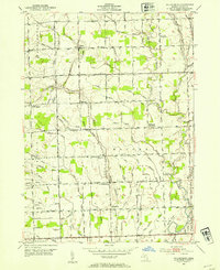
1952 Map of Waldenburg
USGS Topo · Published 1954About this map
Waldenburg and the surrounding townships of Washington, Macomb, and Sterling appear here in a landscape defined by an intricate network of drainage ditches and the meandering Middle Branch Clinton River. This 1952 survey, mapped during the tenure of State Highway Commissioner CHARLES M. ZIEGLER, illustrates a rural Michigan crossroads economy transitioning toward modernization. The map reveals a high density of local educational institutions, ranging from the Lutheran Sch and St Peters Sch to several already marked as defunct, such as the Warner Sch (Abandoned). Small agricultural hubs like Davis, Meade, and Preston Corners anchor the grid of section-line roads, including Romeo Plank Road and Schoenherr Road. The naming conventions of the many artificial waterways, such as the Feiblecorn Drain and Heida Drain, offer significant clues for genealogists researching the land-owning families of the early 1950s.
Find a feature on this map
79 named features on this map. Tap any name to fly to it.
Don’t see what you’re looking for? This feature index may not catch every label — zoom into the map to look around manually.
Map Details
Editions of this 1952 Waldenburg Map
2 editions found
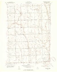
Other maps of this area

1908 · Rochester
USGS Topo · 1:62,500

1912 · Mt Clemens
USGS Topo · 1:62,500

1914 · Armada
USGS Topo · 1:62,500

1928 · Armada
USGS Topo · 1:62,500

1929 · Mt Clemens
USGS Topo · 1:62,500

1936 · Warren
USGS Topo · 1:31,680

1936 · New Haven
USGS Topo · 1:31,680

1936 · Washington
USGS Topo · 1:31,680

1936 · Waldenburg
USGS Topo · 1:31,680

1936 · Selfridge Field
USGS Topo · 1:31,680
Featured Places
- Sterling Heights, MI
- Clinton Township, MI
- Macomb Township, MI
- Shelby Charter Township, MI
- Washington Charter Township, MI