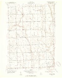
1952 Map of Waldenburg
USGS Topo · Published 1954About this map
Waldenburg and the surrounding townships of Washington, Ray, and Macomb reflect a landscape of well-established mile-grid farming during the early 1950s. The area is defined by the convergence of the Middle Branch Clinton River and the North Branch Clinton River, with an intricate network of local drains like Heida Drain and Feiblecorn Drain managing the low-lying terrain. The map captures a moment of transition for local education, as several older institutions like Warner Sch and Whitney Sch are marked as abandoned, likely replaced by larger consolidated districts.
Find a feature on this map
89 named features on this map. Tap any name to fly to it.
Don’t see what you’re looking for? This feature index may not catch every label — zoom into the map to look around manually.
Map Details
Editions of this 1952 Waldenburg Map
2 editions found
Other maps of this area

1908 · Rochester
USGS Topo · 1:62,500

1912 · Mt Clemens
USGS Topo · 1:62,500

1914 · Armada
USGS Topo · 1:62,500

1928 · Armada
USGS Topo · 1:62,500

1929 · Mt Clemens
USGS Topo · 1:62,500

1936 · Warren
USGS Topo · 1:31,680

1936 · New Haven
USGS Topo · 1:31,680

1936 · Washington
USGS Topo · 1:31,680

1936 · Waldenburg
USGS Topo · 1:31,680

1936 · Selfridge Field
USGS Topo · 1:31,680
Featured Places
- Sterling Heights, MI
- Clinton Township, MI
- Macomb Township, MI
- Shelby Charter Township, MI
- Washington Charter Township, MI