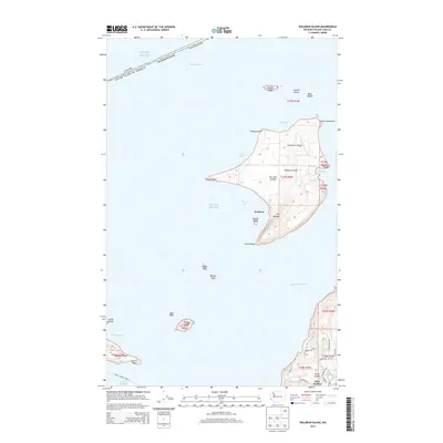
2014 Map of Waldron Island
USGS Topo · Published 2014About this map
Waldron Island sits at the center of this maritime landscape in Puget Sound, defined by its jagged coastline and neighboring archipelagos. The settlement of Waldron is positioned on the island's southern reach near Mt Cement and Point Disney, while the Waldronaire Airport serves the interior. To the south and east, the map captures the northwestern tip of Orcas Island, showing the community of Deer Harbor tucked away near Cornorant Bay Rd. These islands are separated by deep water channels, including President Channel and Boundary Pass, which forms part of the international border with Canada. Numerous smaller landforms such as Flattop Island, the Cactus Islands, and Skipjack Island dot the surrounding waters, illustrating the complex geography of the San Juan islands before modern development altered their character.
Find a feature on this map
48 named features on this map. Tap any name to fly to it.
Don’t see what you’re looking for? This feature index may not catch every label — zoom into the map to look around manually.
Map Details
Editions of this 2014 Waldron Island Map
This is the sole edition of this map. No revisions or reprints were ever made.
Other maps of this area

1943 · Orcas Island
USGS Topo · 1:62,500

1953 · Stuart Island
USGS Topo · 1:24,000

1954 · Roche Harbor
USGS Topo · 1:24,000

1954 · Waldron Island
USGS Topo · 1:24,000

1954 · Friday Harbor
USGS Topo · 1:24,000

1957 · Orcas Island
USGS Topo · 1:62,500

1957 · Victoria
USGS Topo · 1:250,000

1973 · Sucia Island
USGS Topo · 1:24,000

1973 · Shaw Island
USGS Topo · 1:24,000

1975 · Bellingham
USGS Topo · 1:100,000