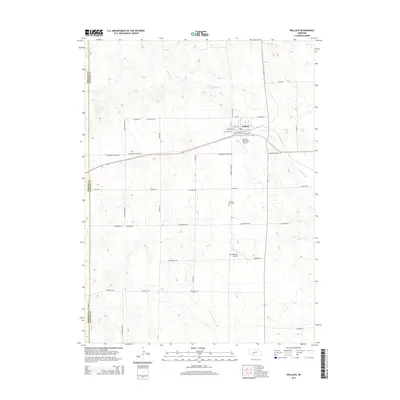
2014 Map of Wallace
USGS Topo · Published 2014About this map
Wallace serves as the central hub of this agricultural landscape in Lincoln County, where the street grid is defined by its connection to the rail line, with names like N Railroad St and E William St anchoring the town. The surrounding terrain is dissected by the seasonal drainage of Red Willow Cr and Dry Cr, which carve shallow paths through the high plains. Local aviation is well-represented by both the Wallace Municipal Airport and the private Van Boening Airport, highlighting the region's reliance on air travel for distance management. Genealogists will find the Morning View Cem situated south of town along Morning View Rd, a quiet landmark in a vast network of section-line roads such as W Andersen Rd and W Medicine Rd that divide the rural territory into a precise geometric pattern.
Find a feature on this map
38 named features on this map. Tap any name to fly to it.
Don’t see what you’re looking for? This feature index may not catch every label — zoom into the map to look around manually.
Map Details
Editions of this 2014 Wallace Map
This is the sole edition of this map. No revisions or reprints were ever made.
Other maps of this area

1954 · McCook
USGS Topo · 1:250,000

1957 · McCook
USGS Topo · 1:250,000

1958 · McCook
USGS Topo · 1:250,000
1973 · Grainton
USGS Topo · 1:24,000

1973 · Dittons Creek NE
USGS Topo · 1:24,000

1973 · Suttlers Canyon West
USGS Topo · 1:24,000
1973 · Wallace NE
USGS Topo · 1:24,000
1973 · Melton Ranch Airport
USGS Topo · 1:24,000
1973 · Wallace NW
USGS Topo · 1:24,000
1973 · Wallace
USGS Topo · 1:24,000