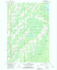
1982 Map of Wallace
USGS Topo · Published 1983About this map
The Chicago and North Western railroad forms the spine of this Upper Peninsula landscape, connecting the rural communities of Wallace, Carbondale, and Ingalls during the early 1980s. This survey illustrates a region defined by its timber and aggregate resources, with much of the eastern terrain preserved within the Escanaba River State Forest. Local life is anchored by established landmarks such as the Mellen Sch and several country churches, including Gethsemane Ch and Bethel Mission Ch. The network of water bodies, from Hanson Lake to the meandering Little River, dictates the placement of early routes like Wildwood Road and the Pinewood Loop. Numerous gravel pits scattered near the rail line and along Bay De Noc Road highlight the active extraction that supported the area's development and infrastructure.
Find a feature on this map
43 named features on this map. Tap any name to fly to it.
Don’t see what you’re looking for? This feature index may not catch every label — zoom into the map to look around manually.
Map Details
Editions of this 1982 Wallace Map
This is the sole edition of this map. No revisions or reprints were ever made.
Other maps of this area

1939 · Marinette
USGS Topo · 1:48,000

1949 · Stephenson
USGS Topo · 1:48,000

1954 · Escanaba
USGS Topo · 1:250,000

1957 · Escanaba
USGS Topo · 1:250,000

1958 · Escanaba
USGS Topo · 1:250,000

1961 · Chambers Island
USGS Topo · 1:62,500

1963 · Cedar River
USGS Topo · 1:62,500
1963 · Birch Creek
USGS Topo · 1:24,000
1963 · Chappee Rapids
USGS Topo · 1:24,000

1963 · Stephenson
USGS Topo · 1:62,500