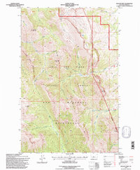
1995 Map of Walling Reef
USGS Topo · Published 1997About this map
Bob Marshall Wilderness and the Lewis and Clark National Forest dominate this Teton County landscape as it was documented in the mid-1990s. The geography is defined by the massive limestone uplift of Walling Reef, a prominent Escarpment that separates the high wilderness interior from the eastern foothills. This region serves as a critical headwaters area, where the North Fork Dupuyer Creek and South Fork Dupuyer Creek emerge from the high ridges to flow eastward toward the plains.
Find a feature on this map
31 named features on this map. Tap any name to fly to it.
Don’t see what you’re looking for? This feature index may not catch every label — zoom into the map to look around manually.
Map Details
Editions of this 1995 Walling Reef Map
This is the sole edition of this map. No revisions or reprints were ever made.
Other maps of this area

1903 · Saypo
USGS Topo · 1:125,000

1914 · Heart Butte
USGS Topo · 1:125,000

1918 · Heart Butte
USGS Topo · 1:125,000

1955 · Choteau
USGS Topo · 1:250,000

1957 · Choteau
USGS Topo · 1:250,000

1958 · Choteau
USGS Topo · 1:250,000

1958 · Cave Mountain
USGS Topo · 1:24,000

1958 · Porphyry Reef
USGS Topo · 1:24,000

1958 · Mount Wright
USGS Topo · 1:24,000

1960 · Cut Bank
USGS Topo · 1:250,000