
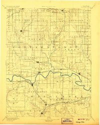
1894 Map of Wamego
USGS Topo · Published 1894About this map
The Kansas River carves a serpentine path through this late nineteenth-century landscape, serving as the central artery for a region defined by its expanding rail networks. Surveyed in 1886, this area showcases the arrival of the Union Pacific Railroad and the Chicago Rock Island & Pacific Railroad, which fueled the growth of towns like Wamego and Alma. Smaller settlements such as Westmoreland and Louisville appear as established community hubs north of the river, while the south is characterized by the rugged terrain around Buffalo Mound and the winding course of Mill Creek. A significant branch of the Atchison Topeka and Santa Fe Railroad cuts south toward Alma, illustrating the competition between lines to secure access to the agricultural heartland of Pottawatomie and Wabaunsee counties. Numerous creeks like Vermillion River and Deep Creek provide a detailed look at the drainage patterns that dictated early road and township boundaries.
Find a feature on this map
81 named features on this map. Tap any name to fly to it.
Don’t see what you’re looking for? This feature index may not catch every label — zoom into the map to look around manually.
Map Details
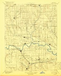
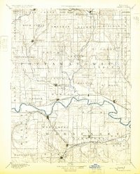
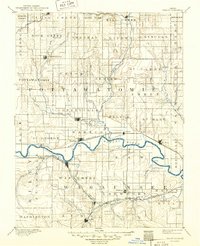
Editions of this 1894 Wamego Map
5 editions found
Other maps of this area

1885 · Eskridge
USGS Topo · 1:125,000

1886 · Junction City
USGS Topo · 1:125,000

1888 · Hiawatha
USGS Topo · 1:125,000

1889 · Burlingame
USGS Topo · 1:125,000

1889 · Seneca
USGS Topo · 1:125,000

1889 · Wamego
USGS Topo · 1:125,000

1889 · Marysville
USGS Topo · 1:125,000

1889 · Junction City
USGS Topo · 1:125,000

1889 · Parkerville
USGS Topo · 1:125,000

1889 · Eskridge
USGS Topo · 1:125,000